Home / Zoning Regulation / The Zoning Ordinance of 2020 /
Art. IV - Zone Classifications
Sec. 5: Division into Zones or Sub-Zones
Sec. 6: Base Zones
Sec. 7: Overlay Zones
Updated March 19, 2023
Discover the provisions of the municipal zoning ordinance of Rosario, Batangas through a series of informative blog posts. Learn about zoning classifications, land use regulations, and more.
Republic of the Philippines
MUNICIPALITY OF ROSARIO
Province of Batangas
COMPREHENSIVE LAND USE PLAN AND ZONING ORDINANCE: 2016-2030
VOLUME 2 - THE ZONING ORDINANCE
Version 6.1 with PLUC Comments Adopted
Article IV – Zone Classifications
Section 5. Division into Zones or Sub-Zones
To effectively carry out the provisions of this Ordinance, the municipality is hereby divided into four (4) Municipal Districts derived from its subwatershed boundaries as follows:
01. The South East Municipal District (Rosario River Subwatershed);
02. The East Municipal District (Lawaye River Subwatershed);
03. The North East Municipal District (Malaquing Ilog River Subwatershed); and
04. The West Municipal District (Calumpang River Subwatershed).
To further effectively carry out the provisions of this Ordinance, the municipality is hereby divided into the following zones as shown in the Official Zoning Maps:
Forest Zone
Agricultural Zone
Municipal Waters Zone
Mineral Land Zone
Residential Zone
Commercial Zone
Agro-Industrial Zone
Industrial Zone
Institutional Zone
Tourism Zone
Cemetery /Memorial Park, Buffer/ Greenbelt and Utilities, Transportation and Services Zone
Utilities, Transportation and Services Zone
Section 6. Base Zones
The following are designated as Base Zones:
a) Forest Zone (FZ)
1) Protection Forest Sub-Zones
i. Forest Reserve Sub-Zone (FR-SZ)
ii. NIPAS: Strict Protection Sub-Zone (NSP-SZ)
2) Production Forest Sub-Zones
b) Agricultural Zone (AGZ)
1) Protection Agricultural Sub-Zone (PTA-SZ)
2) Production Agricultural Sub-Zone (PDA-SZ)
c) Agri-industrial Zone (AgIndZ)
d) Municipal Waters Zone (WZ)
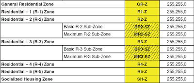
e) Residential-1 Zone (R1-Z)
f) Residential-2 Zone (R2-Z)
1) Basic R-2 Sub-Zone (BR2-SZ)
2) Maximum R-2 Sub-Zone (MR2-SZ)
g) Commercial-1 Zone (C1-Z)
h) Commercial-2 Zone (C2-Z)
i) Industrial-1 Zone (I1-Z)
j) Industrial-2 Zone (I2-Z)
k) Industrial-3 Zone (I3-Z)
l) General Institutional Zone (GI-Z)
m) Parks and Recreation Zone (PR-Z)
n) Cemetery/Memorial Park Zone (C/MP-Z)
o) Buffer/Greenbelt Zone (B/G-Z)
p) Utilities, Transportation, and Services Zone (UTS-SZ)
q) Tourism Zone (T-Z)
Section 7. Overlay Zones
The following are designated as Overlay Zones:
a) Landslide Overlay Zone (LSD-OZ)
b) Flood Overlay Zone (FLD-OZ)
c) Scenic Corridor Overlay Zone (SCD-OZ)
d) Active Fault Overlay Zone (FLT-OZ)
e) Heritage Overlay Zone (HTG-OZ)
f) Ecotourism Overlay Zone (ETM-OZ)
g) Urban Corridor Overlay Zone (UCD-OZ)
h) Transit-Oriented Development Overlay Zone (TOD-OZ)
i) Billboards Overlay Zone (BB-OZ)
j) Key Biodiversity Area Overlay Zone (KBA-OZ)
k) Critical Habitat Overlay Zone (CH-OZ)
ZONING REVIEWER COMMENT
This section of the Zoning Ordinance lays out the different zones and sub-zones in the municipality, which are divided into four municipal districts derived from subwatershed boundaries. The different base zones include Forest, Agricultural, Municipal Waters, Residential, Commercial, Agro-Industrial, Institutional, Tourism, Cemetery/Memorial Park, Buffer/Greenbelt, and Utilities, Transportation, and Services Zones. Overlay zones are also designated, such as Landslide, Flood, Scenic Corridor, Active Fault, Heritage, Ecotourism, Urban Corridor, Transit-Oriented Development, Billboards, Key Biodiversity Area, and Critical Habitat Overlay Zones. These zones and sub-zones serve to effectively carry out the provisions of the Zoning Ordinance.


No comments:
Post a Comment